You picture easing out of your backyard canal and hitting blue water in minutes. In Key Haven, that dream is real, but the details matter. Depth, dock permits, flood risk, and insurance can make two similar-looking homes perform very differently. In this guide, you’ll learn how Key Haven’s lots, canals, and rules work so you can buy with confidence and avoid costly surprises. Let’s dive in.
Why Key Haven draws boaters
Key Haven sits just northeast of Key West with fast connections to Cow Key and Stock Island channels. The neighborhood is close, quiet, and built for boat access. Many streets end in canals, and a handful of homes sit on open water with quicker runs to the Atlantic.
The island is low-lying, and parts of it sit only a couple of feet above high tide. Historical flood events, like Hurricane Wilma’s surge in 2005, are part of local memory. That context makes flood due diligence essential. For location and background, review the neighborhood overview on Key Haven’s Wikipedia page.
Flood risk and elevation basics
You should verify the flood zone, Base Flood Elevation, and the home’s lowest-floor elevation before you fall in love with a property. Pull the property’s panel at the FEMA Flood Map Service Center, and ask the seller for any Elevation Certificate and flood-claim history. Lenders and insurers rely on this paperwork to price your policy and approve financing.
In the Keys, elevated living areas, proper flood vents, and impact-rated openings are common resilience features. These reduce risk and can improve insurability. Expect to compare both an NFIP quote and a private-market flood quote early in your process.
Lot and dock types in Key Haven
Canal-front lots
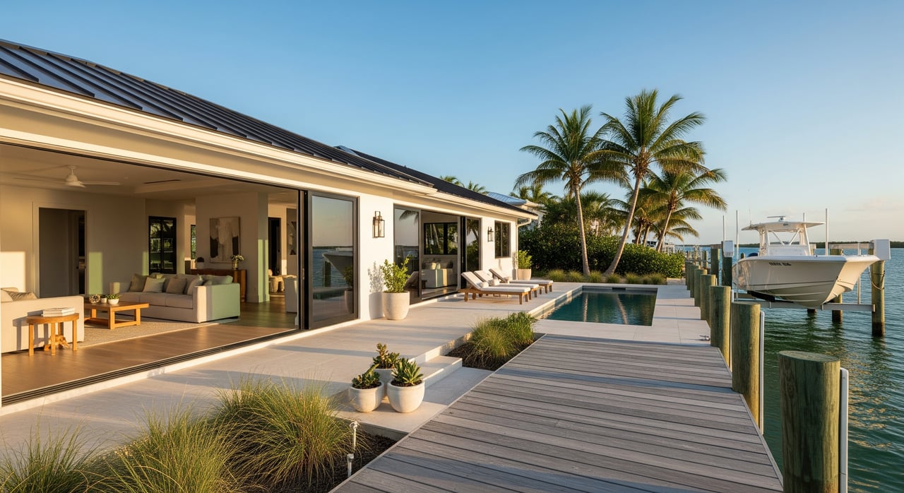
Most Key Haven homes sit on man-made canals. These lots are popular because you get backyard boat access and a shorter price jump than open water. Usability depends on canal width, depth at low tide, and turning room. A long dock or lift does not guarantee your boat can get in and out at mean low water.
Open-water frontage
A smaller number of homes have open-water exposure with fewer approach constraints. These often carry higher prices because they offer faster runs to deeper water and more flexibility for docking. Confirm approach depths even here, especially near flats or shoal-prone areas.
Interior lots
Interior lots sit off the water. They are a fit if you value Key Haven’s location but do not need a private dock. Some buyers pair an interior home with a leased slip elsewhere.
Dock features that matter
Listings will mention pilings, platforms, finger piers, or floating docks. You will also see power pedestals, water hookups, lighting, and various lift types. Ask for the lift’s rated capacity and confirm it covers your boat’s fully loaded weight, including fuel, water, and gear.
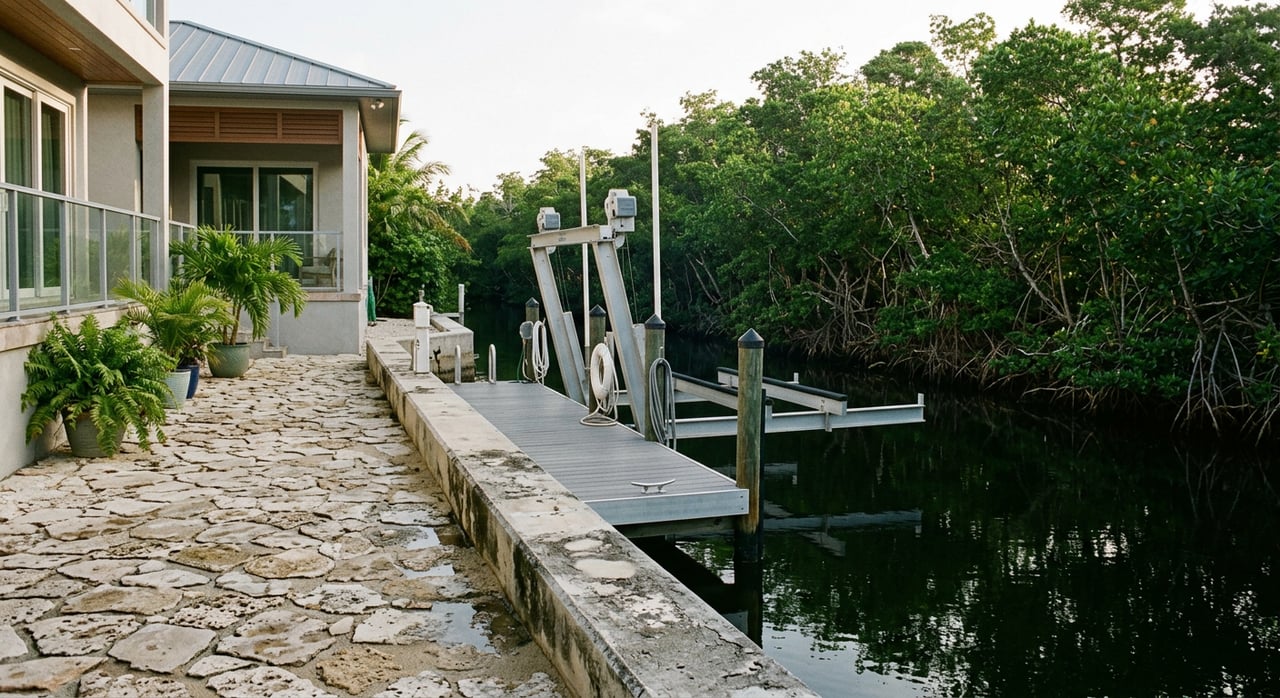
Seawall condition is a major cost driver. Look for cracks, a failing cap, corrosion, or signs of undermining. If work has been done, ask for permits and contractor records. Federal filings in the Keys show that modern seawalls and dredging approvals are common but closely regulated, as you can see in this U.S. Army Corps public notice example.
The most important dock variable is depth at low tide. If the approach shoals to 2 or 3 feet, your boat choice and resale pool shrink. Ask for recent depth soundings taken at a low-tide datum and the name of the surveyor.
Boating access and navigation
Getting to deeper water
Most Key Haven canals connect into the Stock Island and Cow Key Channel system. From there, you are a short ride from Hawk Channel and offshore runs when draft and air-draft allow. For a visual, review the Key Haven and Stock Island channel map.
Cow Key Channel cautions
Cow Key Channel is narrow and can be shallow in places that change with storms and seasons. Some aids to navigation are private. There are also fixed highway bridges and an overhead cable nearby that limit air draft on certain routes. Always verify current controlling depths and clearances for your intended path. Local boating resources note these issues for Cow Key Channel.
Permits and environmental rules
In the Florida Keys, in-water work gets multiple reviews. Many projects need a state Environmental Resource Permit, and some qualify for exemptions. Federal authorizations can apply in navigable waters, and the Florida Keys National Marine Sanctuary may review work that could affect seagrass or coral. Start with the state framework for common exemptions and thresholds in Florida’s ERP rules.
Projection limits, platform sizes, decking height above mean high water, and resource-protection rules can limit what you can build or replace. A dock that looks long in photos might be legally nonconforming, which can affect your ability to modify it. Sanctuary and agency reviews often require mitigation or design tweaks, like grated decking over seagrass. For a sense of how strictly seawalls and dredging get reviewed, see the Army Corps public notice example again, and plan timelines accordingly.
Monroe County enforces local building, floodplain, and land-use rules and is the first stop for permit history. Use the county’s portal to verify what was permitted and when at the Monroe County Building and Permitting site.
Utilities and wastewater
Sewer service has rolled out across the Keys in phases. Whether a property is on central sewer or an onsite system affects monthly costs, approvals for renovations, and environmental compliance. For planning context and parcel-level checks, review county guidance under Planning and Environmental Resources.
Nearby waters include designated no-discharge zones, which means boat sewage must be retained and pumped at approved facilities. This matters for live-aboard use or frequent guests arriving by boat. See sanctuary guidance on water-quality protection and responses in the Florida Keys National Marine Sanctuary materials.
Flood insurance and building resilience
Your flood premium will reflect the FEMA flood zone, Base Flood Elevation, your home’s lowest-floor elevation, foundation type, and prior claims. For waterfront Key Haven addresses, these inputs often push premiums higher than inland properties. Pull the FIRM panel and order or request an Elevation Certificate early from the FEMA Flood Map Service Center.
Homes elevated on pilings, with proper flood vents and impact-rated openings, tend to insure and resell better. If you plan improvements, Monroe County’s floodplain rules and building codes will guide what mitigation is required. You can find permitting references at the Monroe County Building and Permitting site.
What drives price in Key Haven
Market data for ZIP 33040 shows median sold prices in the low-to-mid seven figures, with wide spreads based on lot type and waterfront access. Treat broader ZIP data as context and drill into recent Key Haven waterfront comps with your agent. For an at-a-glance snapshot, see the 33040 market overview.
Features that commonly add value include open-water frontage with a deep, unobstructed approach, long usable dockage, and newer seawalls with documentation. Homes with elevated living areas, impact windows, and hurricane-rated systems also stand out. On the risk side, shallow approaches, narrow turning basins, unpermitted in-water work, aging seawalls, or uncertainty about sewer connection can reduce price or limit your buyer pool later.
Your Key Haven due diligence checklist
Use this short list to keep your search focused and your offer strong.
- Lot type and access
- Canal-front, open-water, or interior. If canal-front, ask for approach depth at mean low water and confirm turning room. A quick review of the local channel map helps frame questions.
- Dock and lift details
- Request permits, as-built drawings, rated lift capacity, and service records. Verify power, water, and lighting are properly protected and metered.
- Seawall condition
- Note material, age, any cap cracks, signs of undermining, and tieback health. Ask for photos of the toe and cap and any repair permits. For reference on how such work is regulated, see the Army Corps public notice example.
- Permits and compliance
- Pull the county file for docks, lifts, seawalls, and any dredging at the Monroe County permitting portal. Align what exists on site with what was approved.
- Bathymetry and navigation
- Ask for recent depth soundings taken at low-tide datum and check intended routes for bridge and cable clearances.
- Flood documentation
- Get the Elevation Certificate, any prior flood claims, and both NFIP and private quotes. Confirm the FEMA panel via the FEMA Flood Map Service Center.
- Utilities and wastewater
- Confirm sewer connection or onsite system details and any county plans that affect the parcel in Planning and Environmental Resources.
- Environmental constraints
- Ask whether mapped seagrass, corals, or protected resources could limit future dock changes. Sanctuary and county staff can advise.
Smart questions to ask on showings
- Can you share the dock and seawall permit history and as-built drawings?
- When were the last bathymetric soundings for the approach, and who did the survey?
- Is the dock or lift fully included in the deed, and are there recorded easements on the water frontage?
- Has the property had flood insurance claims, and do you have an Elevation Certificate?
- Is the home on central sewer, and are there any county plans or assessments that affect this parcel?
- If I need to replace or modify the dock or seawall, what approvals are required and how long do they take?
How a local agent helps you win
In the Keys, a waterfront purchase is part lifestyle and part engineering project. A strong local agent coordinates county permit pulls, lines up a marine surveyor for pilings and docks, orders an Elevation Certificate, and gets insurance quotes early so you see true carrying costs. The right partner also brings trusted marine contractors to estimate seawall or lift work before you write the offer, and can tap local environmental contacts if you plan dock changes.
If you are ready to explore Key Haven, connect with a Keys-native advisor who combines practical property insight with a vetted vendor network. Reach out to Christopher Tanaka to start your waterfront search on solid footing.
FAQs
What makes Key Haven waterfront different from other Keys neighborhoods?
- The island is close to Key West, heavily canalized, and very low-lying, which puts more weight on depth at low tide, turning room, and flood documentation for each specific parcel.
How do I verify canal depth and turning room before I offer?
- Ask for recent low-tide soundings from a licensed surveyor and confirm the measured turning basin; pair that with a quick review of intended routes for bridge and cable clearances.
What permits do I need to replace a dock in the Florida Keys?
- Expect state review under the Environmental Resource Permit program, federal review in navigable waters, possible sanctuary review, and Monroe County approvals; timelines and designs depend on site conditions like seagrass.
How does flood insurance affect Key Haven homes?
- Premiums reflect FEMA flood zone, Base Flood Elevation, your home’s lowest-floor elevation, and prior claims; elevated construction and mitigation features often improve insurability and resale.
Is Cow Key Channel deep enough for my boat?
- Depths change with storms and seasons and some aids are private, so verify current controlling depths near bridges and confirm your boat’s draft and air-draft against those limits.
Do I own the bottom under my dock in Key Haven?
- Not always; docks that extend over state sovereign submerged lands can require state leases or easements, so have your agent and closing team confirm ownership and any recorded agreements early.